


2019 10 03

Ardeiserois
User

Length
101 km

Max alt
480 m

Uphill gradient
1276 m
Km-Effort
118 km

Min alt
201 m

Downhill gradient
1276 m
Boucle
Yes
Creation date :
2019-10-03 19:32:13.646
Updated on :
2019-11-12 21:17:30.106
4h13
Difficulty : Medium

FREE GPS app for hiking
 SityTrail
IGN / Geographical institutes
SityTrail Plus
The world is yours!
About
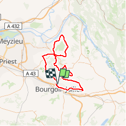
Trail Cycle of 101 km to be discovered at Auvergne-Rhône-Alpes, Isère, Bourgoin-Jallieu. This trail is proposed by Ardeiserois.
Positioning
Country:
France
Region :
Auvergne-Rhône-Alpes
Department/Province :
Isère
Municipality :
Bourgoin-Jallieu
Location:
Unknown
Start:(Dec)
Start:(UTM)
677186 ; 5052876 (31T) N.
Comments