


La Roche Blanche

drarep
User
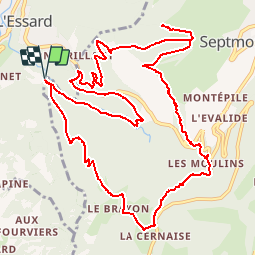

Length
14.6 km

Max alt
1141 m

Uphill gradient
1095 m
Km-Effort
29 km

Min alt
447 m

Downhill gradient
1096 m
Boucle
Yes
Creation date :
2019-10-03 21:46:36.382
Updated on :
2019-10-21 08:44:51.583
7h06
Difficulty : Difficult

FREE GPS app for hiking
 SityTrail
IGN / Geographical institutes
SityTrail Plus
The world is yours!
About
Trail Walking of 14.6 km to be discovered at Bourgogne-Franche-Comté, Jura, Villard-Saint-Sauveur. This trail is proposed by drarep.
Positioning
Country:
France
Region :
Bourgogne-Franche-Comté
Department/Province :
Jura
Municipality :
Villard-Saint-Sauveur
Location:
Unknown
Start:(Dec)
Start:(UTM)
721402 ; 5138621 (31T) N.
Comments