


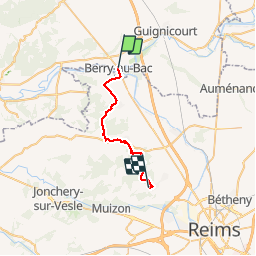
Berry au Bac - Merfy

VANDERPUTTENMi
User GUIDE

Length
21 km

Max alt
216 m

Uphill gradient
302 m
Km-Effort
25 km

Min alt
51 m

Downhill gradient
221 m
Boucle
No
Creation date :
2019-10-04 07:38:37.846
Updated on :
2019-10-06 12:21:21.749
5h19
Difficulty : Very easy

FREE GPS app for hiking
 SityTrail
IGN / Geographical institutes
SityTrail Plus
The world is yours!
About
Trail Walking of 21 km to be discovered at Hauts-de-France, Aisne, Berry-au-Bac. This trail is proposed by VANDERPUTTENMi.
Description
Linéaire sur la Via Francigéna GR145, depuis Berry au Bac jusque Merfy
Positioning
Country:
France
Region :
Hauts-de-France
Department/Province :
Aisne
Municipality :
Berry-au-Bac
Location:
Unknown
Start:(Dec)
Start:(UTM)
565308 ; 5472672 (31U) N.
Comments