


2019-10-12 Rando CVA Reipertswiller vers Lichtenberg

holtzv
User GUIDE
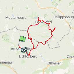

Length
29 km

Max alt
419 m

Uphill gradient
830 m
Km-Effort
40 km

Min alt
197 m

Downhill gradient
734 m
Boucle
No
Creation date :
2019-10-05 15:52:13.88
Updated on :
2019-10-14 15:03:55.056
2h25
Difficulty : Easy

FREE GPS app for hiking
 SityTrail
IGN / Geographical institutes
SityTrail Plus
The world is yours!
About
Trail Horseback riding of 29 km to be discovered at Grand Est, Bas-Rhin, Reipertswiller. This trail is proposed by holtzv.
Photos


Positioning
Country:
France
Region :
Grand Est
Department/Province :
Bas-Rhin
Municipality :
Reipertswiller
Location:
Unknown
Start:(Dec)
Start:(UTM)
387129 ; 5421756 (32U) N.
Comments