


Chapelle St Christophe

ajd26
User

Length
17 km

Max alt
702 m

Uphill gradient
547 m
Km-Effort
24 km

Min alt
305 m

Downhill gradient
547 m
Boucle
Yes
Creation date :
2019-10-05 08:10:40.0
Updated on :
2019-10-07 16:33:03.927
6h00
Difficulty : Medium

FREE GPS app for hiking
 SityTrail
IGN / Geographical institutes
SityTrail Plus
The world is yours!
About
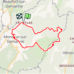
Trail Walking of 17 km to be discovered at Auvergne-Rhône-Alpes, Drôme, Montclar-sur-Gervanne. This trail is proposed by ajd26.
Description
Départ de Vaugelas, col de La Croix, chapelle et retour par Montclar. Rando ombragée avec de beaux points de vue
Positioning
Country:
France
Region :
Auvergne-Rhône-Alpes
Department/Province :
Drôme
Municipality :
Montclar-sur-Gervanne
Location:
Unknown
Start:(Dec)
Start:(UTM)
670439 ; 4958650 (31T) N.
Comments