


Sentiers // route du Fenouillet

jmheydorff
User
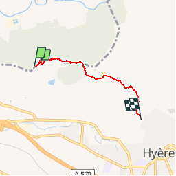

Length
3.9 km

Max alt
252 m

Uphill gradient
102 m
Km-Effort
5.5 km

Min alt
128 m

Downhill gradient
188 m
Boucle
No
Creation date :
2019-10-06 08:10:40.0
Updated on :
2019-10-06 09:37:25.36
1h26
Difficulty : Very difficult

FREE GPS app for hiking
 SityTrail
IGN / Geographical institutes
SityTrail Plus
The world is yours!
About
Trail Walking of 3.9 km to be discovered at Provence-Alpes-Côte d'Azur, Var, Hyères. This trail is proposed by jmheydorff.
Positioning
Country:
France
Region :
Provence-Alpes-Côte d'Azur
Department/Province :
Var
Municipality :
Hyères
Location:
Unknown
Start:(Dec)
Start:(UTM)
263993 ; 4779963 (32T) N.
Comments