


Florennes Course à pied

daniel_2w
User
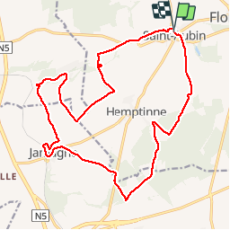

Length
19.9 km

Max alt
298 m

Uphill gradient
276 m
Km-Effort
24 km

Min alt
217 m

Downhill gradient
275 m
Boucle
Yes
Creation date :
2019-10-06 18:13:40.857
Updated on :
2019-10-24 19:43:01.859
--
Difficulty : Very easy

FREE GPS app for hiking
 SityTrail
IGN / Geographical institutes
SityTrail Plus
The world is yours!
About
Trail On foot of 19.9 km to be discovered at Wallonia, Namur, Florennes. This trail is proposed by daniel_2w.
Positioning
Country:
Belgium
Region :
Wallonia
Department/Province :
Namur
Municipality :
Florennes
Location:
Saint-Aubin
Start:(Dec)
Start:(UTM)
612483 ; 5567385 (31U) N.
Comments