


Le Mollard depart Sisteron gendarmerie

claude nier
User
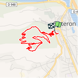

Length
5.9 km

Max alt
738 m

Uphill gradient
305 m
Km-Effort
10 km

Min alt
499 m

Downhill gradient
315 m
Boucle
Yes
Creation date :
2019-10-07 06:13:37.082
Updated on :
2019-10-07 11:17:30.696
2h22
Difficulty : Easy

FREE GPS app for hiking
 SityTrail
IGN / Geographical institutes
SityTrail Plus
The world is yours!
About
Trail Walking of 5.9 km to be discovered at Provence-Alpes-Côte d'Azur, Alpes-de-Haute-Provence, Sisteron. This trail is proposed by claude nier.
Description
rando sympa ...a decouvrir
Positioning
Country:
France
Region :
Provence-Alpes-Côte d'Azur
Department/Province :
Alpes-de-Haute-Provence
Municipality :
Sisteron
Location:
Unknown
Start:(Dec)
Start:(UTM)
735052 ; 4897710 (31T) N.
Comments