


depart station de laye ; rocher du midi

gerardmicheline
User
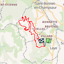

Length
17 km

Max alt
1818 m

Uphill gradient
992 m
Km-Effort
30 km

Min alt
1158 m

Downhill gradient
991 m
Boucle
Yes
Creation date :
2019-10-07 13:01:11.976
Updated on :
2019-10-07 13:03:03.849
--
Difficulty : Difficult

FREE GPS app for hiking
 SityTrail
IGN / Geographical institutes
SityTrail Plus
The world is yours!
About
Trail On foot of 17 km to be discovered at Provence-Alpes-Côte d'Azur, Hautes-Alpes, Laye. This trail is proposed by gerardmicheline.
Positioning
Country:
France
Region :
Provence-Alpes-Côte d'Azur
Department/Province :
Hautes-Alpes
Municipality :
Laye
Location:
Unknown
Start:(Dec)
Start:(UTM)
267969 ; 4947400 (32T) N.
Comments