


Gévezé Vignoc

chasle
User
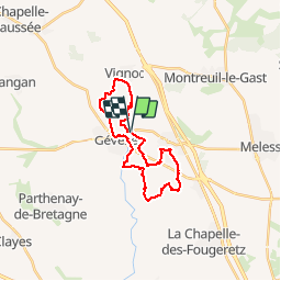

Length
22 km

Max alt
105 m

Uphill gradient
249 m
Km-Effort
25 km

Min alt
49 m

Downhill gradient
244 m
Boucle
Yes
Creation date :
2019-10-07 20:12:28.872
Updated on :
2019-10-07 20:44:00.629
5h27
Difficulty : Easy

FREE GPS app for hiking
 SityTrail
IGN / Geographical institutes
SityTrail Plus
The world is yours!
About
Trail Walking of 22 km to be discovered at Brittany, Ille-et-Vilaine, Gévezé. This trail is proposed by chasle.
Description
Export from GpsPrune
Positioning
Country:
France
Region :
Brittany
Department/Province :
Ille-et-Vilaine
Municipality :
Gévezé
Location:
Unknown
Start:(Dec)
Start:(UTM)
590595 ; 5341923 (30U) N.
Comments