Trail Mountain bike Dinant - Circuit VTT jaune - Photo

Circuit VTT jaune

© OpenStreetMap contributors
Length
Length
22 km
Max alt
Max alt
291 m
Uphill gradient
Uphill gradient
515 m
Km-Effort
Km-Effort  
29 km
Min alt
Min alt
95 m
Downhill gradient
Downhill gradient
514 m
Boucle
Boucle
Yes
Creation date :
2019-10-08 08:03:01.102
Updated on :
2019-10-08 08:07:53.037

(0 Reviews)

Mountain bike
Mountain bike
1h51
Difficulty : Medium

Scan this QR Code to open this trail in the SityTrail application

FREE GPS app for hiking

Logo SityTrail SityTrail

IGN / Geographical institutes

Download SityTrail from the App Store Download SityTrail from Google Play

Logo SityTrail SityTrail World

The world is yours!

Download SityTrail from the App Store Download SityTrail from Google Play Download SityTrail on Huawei AppGallery

About

Trail Mountain bike of 22 km to be discovered at Wallonia, Namur, Dinant. This trail is proposed by ValleedelaMeuse.

Description

Départ du rocher Bayard vers Dréhance par le sentier "Dinant Aventure"puis direction Foy, Taviet, Sorinnes. Retour par la plaine de l'observatoire à Herbuchenne.Grande descente dans les bois vers le rocher.

Elevation profile

Positioning

Country:
Belgium
Region :
Wallonia
Department/Province :
Namur
Municipality :
Dinant
Location:
Dinant
Start:(UTM)
637011 ; 5567443 (31U) N.

Trails nearby

Trail Walking Houyet - Nature - The Payenne trail (Houyet) - Photo
Walking
PRO

Walking

Difficult
(5)
Houyet, Wallonia, Namur, Belgium
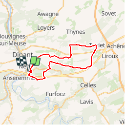
14.3 km | 19 km-effort
4h 18min
Yes
Trail Walking Houyet - La Lesse, Natura 2000 - Des sites qui valent le détour, Na07 - Photo
Walking
GUIDE+

Walking

Difficult
(9)
Houyet, Wallonia, Namur, Belgium
8.8 km | 11.5 km-effort
2h 33min
Yes
Trail Walking Houyet - GG-NA-20_Gendron-Celles - Dinant - Photo
Walking
PRO

Walking

Very difficult
(4)
Houyet, Wallonia, Namur, Belgium
23 km | 30 km-effort
6h 27min
No
Trail Walking Dinant - Balade à Dinant - La Réserve Naturelle de Moniat - Photo
Walking
GUIDE
Desrumaux

Walking

Very easy
(1)
Dinant, Wallonia, Namur, Belgium
8.4 km | 10.9 km-effort
3h 54min
Yes
Trail Walking Dinant - D'Anseremme à Dinant - Photo
Walking
GUIDE
Desrumaux

Walking

Easy
(3)
Dinant, Wallonia, Namur, Belgium
8.3 km | 11.8 km-effort
2h 34min
Yes
Trail Walking Houyet - Gendron trail - Lesse Valley Roadbook - Photo
Walking
PRO

Walking

Medium
(4)
Houyet, Wallonia, Namur, Belgium
7.1 km | 9.2 km-effort
1h 58min
Yes
Trail Walking Dinant - Balade à Bouvignes - Photo
Walking
GUIDE
Desrumaux

Walking

Easy
(3)
Dinant, Wallonia, Namur, Belgium
4.8 km | 7.2 km-effort
1h 34min
Yes
Trail Walking Dinant - Balade en Réserve Naturelle de Devant Bouvignes - Photo
Walking
GUIDE
Desrumaux

Walking

Very easy
(3)
Dinant, Wallonia, Namur, Belgium
4.9 km | 6.9 km-effort
1h 32min
Yes
Trail Walking Dinant - Dinant: autour de la Citadelle.  - Photo
Walking
godi

Walking

Easy
(4)
Dinant, Wallonia, Namur, Belgium
5.7 km | 7.5 km-effort
1h 40min
Yes


Close
My subscriptions