


Les Praz Chamonix

Childebert
User
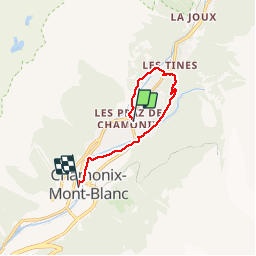

Length
7.8 km

Max alt
1169 m

Uphill gradient
139 m
Km-Effort
9.7 km

Min alt
1036 m

Downhill gradient
164 m
Boucle
No
Creation date :
2019-10-08 11:58:55.529
Updated on :
2019-10-08 14:51:35.858
2h50
Difficulty : Easy

FREE GPS app for hiking
 SityTrail
IGN / Geographical institutes
SityTrail Plus
The world is yours!
About
Trail Walking of 7.8 km to be discovered at Auvergne-Rhône-Alpes, Upper Savoy, Chamonix-Mont-Blanc. This trail is proposed by Childebert.
Positioning
Country:
France
Region :
Auvergne-Rhône-Alpes
Department/Province :
Upper Savoy
Municipality :
Chamonix-Mont-Blanc
Location:
Unknown
Start:(Dec)
Start:(UTM)
336331 ; 5089506 (32T) N.
Comments