


champsaur 2020; depart les tourrengs

gerardmicheline
User
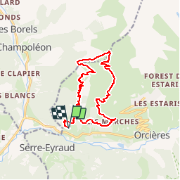

Length
15.5 km

Max alt
2468 m

Uphill gradient
1199 m
Km-Effort
31 km

Min alt
1309 m

Downhill gradient
1199 m
Boucle
Yes
Creation date :
2019-10-09 12:33:52.495
Updated on :
2019-10-09 12:34:49.268
--
Difficulty : Difficult

FREE GPS app for hiking
 SityTrail
IGN / Geographical institutes
SityTrail Plus
The world is yours!
About
Trail On foot of 15.5 km to be discovered at Provence-Alpes-Côte d'Azur, Hautes-Alpes, Orcières. This trail is proposed by gerardmicheline.
Positioning
Country:
France
Region :
Provence-Alpes-Côte d'Azur
Department/Province :
Hautes-Alpes
Municipality :
Orcières
Location:
Unknown
Start:(Dec)
Start:(UTM)
284939 ; 4951622 (32T) N.
Comments