


Sages - Cabo de São Vincent 9-10-2019

fredetpascale
User GUIDE
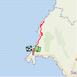

Length
9.5 km

Max alt
90 m

Uphill gradient
184 m
Km-Effort
12 km

Min alt
31 m

Downhill gradient
184 m
Boucle
Yes
Creation date :
2019-10-09 14:54:23.274
Updated on :
2019-10-09 19:34:44.067
2h44
Difficulty : Easy

FREE GPS app for hiking
 SityTrail
IGN / Geographical institutes
SityTrail Plus
The world is yours!
About
Trail Walking of 9.5 km to be discovered at Algarve, Faro, Sagres. This trail is proposed by fredetpascale.
Positioning
Country:
Portugal
Region :
Algarve
Department/Province :
Faro
Municipality :
Sagres
Location:
Unknown
Start:(Dec)
Start:(UTM)
501208 ; 4097885 (29S) N.
Comments