


Calanques de Cassis. Port Pin En Vau

GOHIER
User
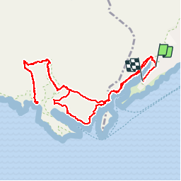

Length
12.9 km

Max alt
186 m

Uphill gradient
572 m
Km-Effort
21 km

Min alt
4 m

Downhill gradient
590 m
Boucle
No
Creation date :
2019-10-05 08:21:20.0
Updated on :
2019-10-10 06:03:19.402
6h52
Difficulty : Unknown

FREE GPS app for hiking
 SityTrail
IGN / Geographical institutes
SityTrail Plus
The world is yours!
About
Trail Walking of 12.9 km to be discovered at Provence-Alpes-Côte d'Azur, Bouches-du-Rhône, Cassis. This trail is proposed by GOHIER.
Description
Beau bon bain
Positioning
Country:
France
Region :
Provence-Alpes-Côte d'Azur
Department/Province :
Bouches-du-Rhône
Municipality :
Cassis
Location:
Unknown
Start:(Dec)
Start:(UTM)
704945 ; 4787268 (31T) N.
Comments