


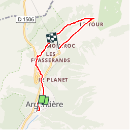
argentiere le tour par chenavier

Childebert
User

Length
5.3 km

Max alt
1545 m

Uphill gradient
309 m
Km-Effort
9 km

Min alt
1243 m

Downhill gradient
180 m
Boucle
No
Creation date :
2019-10-10 12:12:53.564
Updated on :
2019-10-10 14:48:30.957
2h32
Difficulty : Medium

FREE GPS app for hiking
 SityTrail
IGN / Geographical institutes
SityTrail Plus
The world is yours!
About
Trail Walking of 5.3 km to be discovered at Auvergne-Rhône-Alpes, Upper Savoy, Chamonix-Mont-Blanc. This trail is proposed by Childebert.
Positioning
Country:
France
Region :
Auvergne-Rhône-Alpes
Department/Province :
Upper Savoy
Municipality :
Chamonix-Mont-Blanc
Location:
Unknown
Start:(Dec)
Start:(UTM)
339464 ; 5094161 (32T) N.
Comments