


Tarsimoure

ajd26
User
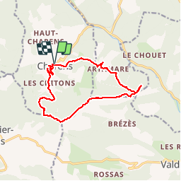

Length
14.3 km

Max alt
1533 m

Uphill gradient
798 m
Km-Effort
25 km

Min alt
840 m

Downhill gradient
797 m
Boucle
Yes
Creation date :
2019-10-10 07:00:16.0
Updated on :
2019-10-14 15:52:22.066
7h05
Difficulty : Medium

FREE GPS app for hiking
 SityTrail
IGN / Geographical institutes
SityTrail Plus
The world is yours!
About
Trail Walking of 14.3 km to be discovered at Auvergne-Rhône-Alpes, Drôme, Charens. This trail is proposed by ajd26.
Description
Depuis Charens, montagne de Tarsimoure, montée et descente raides équipées de câbles. Beaux points de vue en crête
Positioning
Country:
France
Region :
Auvergne-Rhône-Alpes
Department/Province :
Drôme
Municipality :
Charens
Location:
Unknown
Start:(Dec)
Start:(UTM)
699394 ; 4934771 (31T) N.
Comments