


montagne de la blanche

loca.yves
User GUIDE
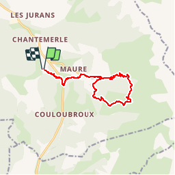

Length
13.6 km

Max alt
1850 m

Uphill gradient
643 m
Km-Effort
22 km

Min alt
1340 m

Downhill gradient
641 m
Boucle
Yes
Creation date :
2019-10-11 07:26:07.535
Updated on :
2019-10-11 13:22:47.769
5h55
Difficulty : Medium

FREE GPS app for hiking
 SityTrail
IGN / Geographical institutes
SityTrail Plus
The world is yours!
About
Trail Walking of 13.6 km to be discovered at Provence-Alpes-Côte d'Azur, Alpes-de-Haute-Provence, Seyne. This trail is proposed by loca.yves.
Positioning
Country:
France
Region :
Provence-Alpes-Côte d'Azur
Department/Province :
Alpes-de-Haute-Provence
Municipality :
Seyne
Location:
Unknown
Start:(Dec)
Start:(UTM)
292138 ; 4910963 (32T) N.
Comments