


Frédéric Pasian - Mairie de Lherm - 2 Novembre 2009

pidjam
User
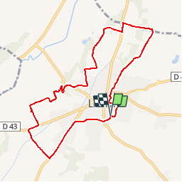

Length
9.6 km

Max alt
232 m

Uphill gradient
102 m
Km-Effort
10.9 km

Min alt
196 m

Downhill gradient
99 m
Boucle
Yes
Creation date :
2019-10-12 11:16:19.047
Updated on :
2019-10-12 11:17:57.712
2h24
Difficulty : Medium

FREE GPS app for hiking
 SityTrail
IGN / Geographical institutes
SityTrail Plus
The world is yours!
About
Trail Walking of 9.6 km to be discovered at Occitania, Haute-Garonne, Lherm. This trail is proposed by pidjam.
Description
rando de la mairie (2009) balisée
Positioning
Country:
France
Region :
Occitania
Department/Province :
Haute-Garonne
Municipality :
Lherm
Location:
Unknown
Start:(Dec)
Start:(UTM)
356300 ; 4809833 (31T) N.
Comments