


Caudebec en caux

pmauvieux
User
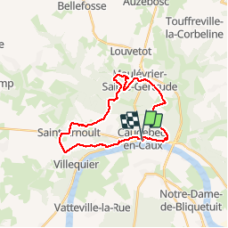

Length
23 km

Max alt
148 m

Uphill gradient
464 m
Km-Effort
29 km

Min alt
6 m

Downhill gradient
471 m
Boucle
Yes
Creation date :
2019-10-12 07:44:36.664
Updated on :
2019-10-12 15:39:34.757
7h37
Difficulty : Medium

FREE GPS app for hiking
 SityTrail
IGN / Geographical institutes
SityTrail Plus
The world is yours!
About
Trail Walking of 23 km to be discovered at Normandy, Seine-Maritime, Rives-en-Seine. This trail is proposed by pmauvieux.
Positioning
Country:
France
Region :
Normandy
Department/Province :
Seine-Maritime
Municipality :
Rives-en-Seine
Location:
Unknown
Start:(Dec)
Start:(UTM)
335206 ; 5488334 (31U) N.
Comments