


2019-10-12_18h40m43_FROIDEVAUX-18-2-kms

gerardmicheline
User
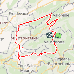

Length
18.1 km

Max alt
816 m

Uphill gradient
539 m
Km-Effort
25 km

Min alt
435 m

Downhill gradient
535 m
Boucle
Yes
Creation date :
2019-10-12 16:40:43.957
Updated on :
2019-10-12 16:40:45.598

FREE GPS app for hiking
 SityTrail
IGN / Geographical institutes
SityTrail Plus
The world is yours!
About
Trail of 18.1 km to be discovered at Bourgogne-Franche-Comté, Doubs, Vauclusotte. This trail is proposed by gerardmicheline.
Positioning
Country:
France
Region :
Bourgogne-Franche-Comté
Department/Province :
Doubs
Municipality :
Vauclusotte
Location:
Unknown
Start:(Dec)
Start:(UTM)
328735 ; 5238604 (32T) N.
Comments