


Fournes traces de rochefort

mthomas30
User
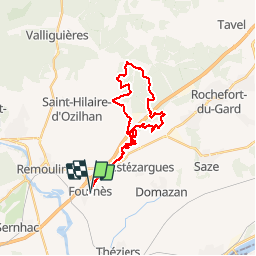

Length
30 km

Max alt
229 m

Uphill gradient
483 m
Km-Effort
36 km

Min alt
51 m

Downhill gradient
483 m
Boucle
Yes
Creation date :
2019-10-13 05:56:18.153
Updated on :
2019-10-13 09:29:24.442
3h31
Difficulty : Difficult

FREE GPS app for hiking
 SityTrail
IGN / Geographical institutes
SityTrail Plus
The world is yours!
About
Trail Mountain bike of 30 km to be discovered at Occitania, Gard, Fournès. This trail is proposed by mthomas30.
Description
technique
Positioning
Country:
France
Region :
Occitania
Department/Province :
Gard
Municipality :
Fournès
Location:
Unknown
Start:(Dec)
Start:(UTM)
628605 ; 4865172 (31T) N.
Comments