


Petit tour à l'étang

StephaneBM
User
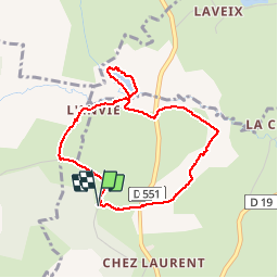

Length
3.6 km

Max alt
773 m

Uphill gradient
74 m
Km-Effort
4.6 km

Min alt
710 m

Downhill gradient
76 m
Boucle
Yes
Creation date :
2019-10-13 08:26:08.313
Updated on :
2019-10-13 09:53:04.456
1h26
Difficulty : Very easy

FREE GPS app for hiking
 SityTrail
IGN / Geographical institutes
SityTrail Plus
The world is yours!
About
Trail Walking of 3.6 km to be discovered at Auvergne-Rhône-Alpes, Puy-de-Dôme, Voingt. This trail is proposed by StephaneBM.
Positioning
Country:
France
Region :
Auvergne-Rhône-Alpes
Department/Province :
Puy-de-Dôme
Municipality :
Voingt
Location:
Unknown
Start:(Dec)
Start:(UTM)
463337 ; 5073293 (31T) N.
Comments