


VTT Domptail 13/10/19

vathi54
User
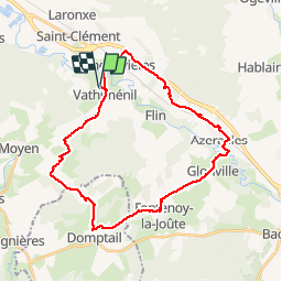

Length
30 km

Max alt
377 m

Uphill gradient
322 m
Km-Effort
34 km

Min alt
239 m

Downhill gradient
323 m
Boucle
Yes
Creation date :
2019-10-13 07:09:35.216
Updated on :
2019-10-13 10:08:36.603
2h58
Difficulty : Easy

FREE GPS app for hiking
 SityTrail
IGN / Geographical institutes
SityTrail Plus
The world is yours!
About
Trail Mountain bike of 30 km to be discovered at Grand Est, Meurthe-et-Moselle, Vathiménil. This trail is proposed by vathi54.
Description
Reprise Fabrice et David
Positioning
Country:
France
Region :
Grand Est
Department/Province :
Meurthe-et-Moselle
Municipality :
Vathiménil
Location:
Unknown
Start:(Dec)
Start:(UTM)
324299 ; 5375607 (32U) N.
Comments