


20191013172628-rsgDx

JLD
User

Length
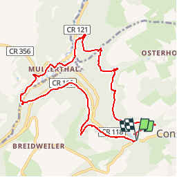
9.4 km

Max alt
352 m

Uphill gradient
231 m
Km-Effort
12.5 km

Min alt
211 m

Downhill gradient
240 m
Boucle
Yes
Creation date :
2019-10-13 15:26:57.367
Updated on :
2019-10-23 13:29:51.053
--
Difficulty : Medium

FREE GPS app for hiking
 SityTrail
IGN / Geographical institutes
SityTrail Plus
The world is yours!
About
Trail On foot of 9.4 km to be discovered at Unknown, Canton Echternach, Consdorf. This trail is proposed by JLD.
Description
A tester

Positioning
Country:
Luxembourg
Region :
Unknown
Department/Province :
Canton Echternach
Municipality :
Consdorf
Location:
Unknown
Start:(Dec)
Start:(UTM)
307638 ; 5517459 (32U) N.
Comments