


Hautefeuille

LaurentBernard
User
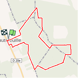

Length
10.1 km

Max alt
134 m

Uphill gradient
80 m
Km-Effort
11.1 km

Min alt
113 m

Downhill gradient
79 m
Boucle
Yes
Creation date :
2019-10-15 09:38:42.78
Updated on :
2019-10-15 09:39:20.737
--
Difficulty : Very easy

FREE GPS app for hiking
 SityTrail
IGN / Geographical institutes
SityTrail Plus
The world is yours!
About
Trail On foot of 10.1 km to be discovered at Ile-de-France, Seine-et-Marne, Hautefeuille. This trail is proposed by LaurentBernard.
Positioning
Country:
France
Region :
Ile-de-France
Department/Province :
Seine-et-Marne
Municipality :
Hautefeuille
Location:
Unknown
Start:(Dec)
Start:(UTM)
497625 ; 5401470 (31U) N.
Comments