


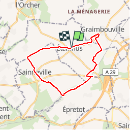
Etainhus Circuit de la Garenne ne points bleus

DDLEDANDY
User

Length
11.9 km

Max alt
127 m

Uphill gradient
123 m
Km-Effort
13.5 km

Min alt
86 m

Downhill gradient
124 m
Boucle
Yes
Creation date :
2019-10-15 07:11:21.575
Updated on :
2019-10-15 09:55:39.003
2h36
Difficulty : Medium

FREE GPS app for hiking
 SityTrail
IGN / Geographical institutes
SityTrail Plus
The world is yours!
About
Trail Walking of 11.9 km to be discovered at Normandy, Seine-Maritime, Étainhus. This trail is proposed by DDLEDANDY.
Positioning
Country:
France
Region :
Normandy
Department/Province :
Seine-Maritime
Municipality :
Étainhus
Location:
Unknown
Start:(Dec)
Start:(UTM)
305625 ; 5494000 (31U) N.
Comments