


2019-10-15_17h19m13_u3l-sFf81n8

gerard70
User
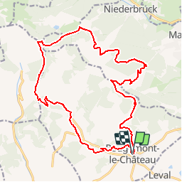

Length
20 km

Max alt
1065 m

Uphill gradient
1008 m
Km-Effort
34 km

Min alt
446 m

Downhill gradient
1010 m
Boucle
Yes
Creation date :
2019-10-15 15:19:15.412
Updated on :
2019-10-20 14:52:27.49
--
Difficulty : Difficult

FREE GPS app for hiking
 SityTrail
IGN / Geographical institutes
SityTrail Plus
The world is yours!
About
Trail On foot of 20 km to be discovered at Bourgogne-Franche-Comté, Territoire-de-Belfort, Rougemont-le-Château. This trail is proposed by gerard70.
Positioning
Country:
France
Region :
Bourgogne-Franche-Comté
Department/Province :
Territoire-de-Belfort
Municipality :
Rougemont-le-Château
Location:
Unknown
Start:(Dec)
Start:(UTM)
347645 ; 5288950 (32T) N.
Comments