


Luciolette 2019. Rando pédrestre.

mthomas30
User
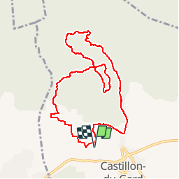

Length
10.1 km

Max alt
166 m

Uphill gradient
165 m
Km-Effort
12.3 km

Min alt
59 m

Downhill gradient
164 m
Boucle
Yes
Creation date :
2019-10-15 15:46:12.09
Updated on :
2019-11-11 18:14:06.966
2h08
Difficulty : Difficult

FREE GPS app for hiking
 SityTrail
IGN / Geographical institutes
SityTrail Plus
The world is yours!
About
Trail Walking of 10.1 km to be discovered at Occitania, Gard, Castillon-du-Gard. This trail is proposed by mthomas30.
Positioning
Country:
France
Region :
Occitania
Department/Province :
Gard
Municipality :
Castillon-du-Gard
Location:
Unknown
Start:(Dec)
Start:(UTM)
624122 ; 4870253 (31T) N.
Comments