


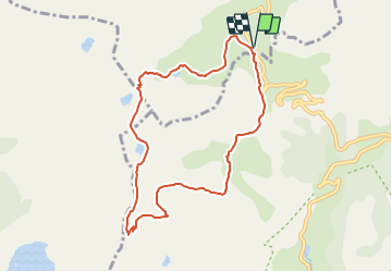
Lac de la petite cayolle

andre06130
User

Length
8.7 km

Max alt
2676 m

Uphill gradient
448 m
Km-Effort
14.7 km

Min alt
2243 m

Downhill gradient
450 m
Boucle
Yes
Creation date :
2014-12-10 00:00:00.0
Updated on :
2022-02-10 16:31:56.284
3h04
Difficulty : Easy

FREE GPS app for hiking
 SityTrail
IGN / Geographical institutes
SityTrail Plus
The world is yours!
About
Trail Walking of 8.7 km to be discovered at Provence-Alpes-Côte d'Azur, Alpes-de-Haute-Provence, Uvernet-Fours. This trail is proposed by andre06130.
Description
superbe vue sur le lac d'Allos
Positioning
Country:
France
Region :
Provence-Alpes-Côte d'Azur
Department/Province :
Alpes-de-Haute-Provence
Municipality :
Uvernet-Fours
Location:
Unknown
Start:(Dec)
Start:(UTM)
319893 ; 4903211 (32T) N.
Comments