


devoluy ane

Liebeaux
User
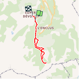

Length
11.8 km

Max alt
1885 m

Uphill gradient
526 m
Km-Effort
18.9 km

Min alt
1472 m

Downhill gradient
560 m
Boucle
No
Creation date :
2019-10-17 07:32:21.402
Updated on :
2019-10-17 13:23:37.596
5h36
Difficulty : Very easy

FREE GPS app for hiking
 SityTrail
IGN / Geographical institutes
SityTrail Plus
The world is yours!
About
Trail Walking of 11.8 km to be discovered at Provence-Alpes-Côte d'Azur, Hautes-Alpes, Le Dévoluy. This trail is proposed by Liebeaux.
Positioning
Country:
France
Region :
Provence-Alpes-Côte d'Azur
Department/Province :
Hautes-Alpes
Municipality :
Le Dévoluy
Location:
Saint-Étienne-en-Dévoluy
Start:(Dec)
Start:(UTM)
732614 ; 4950682 (31T) N.
Comments