Trail Walking Ucel - Bréchignac - Coste d'Haut - Photo

Bréchignac - Coste d'Haut

 pb07
pb07

User

© OpenStreetMap contributors
Length
Length
6.8 km
Max alt
Max alt
472 m
Uphill gradient
Uphill gradient
302 m
Km-Effort
Km-Effort  
10.8 km
Min alt
Min alt
263 m
Downhill gradient
Downhill gradient
297 m
Boucle
Boucle
Yes
Creation date :
2014-12-10 00:00:00.0
Updated on :
2014-12-10 00:00:00.0

(0 Reviews)

Walking
Walking
2h16
Difficulty : Medium

Scan this QR Code to open this trail in the SityTrail application

FREE GPS app for hiking

Logo SityTrail SityTrail

IGN / Geographical institutes

Download SityTrail from the App Store Download SityTrail from Google Play

Logo SityTrail SityTrail Plus

The world is yours!

Download SityTrail from the App Store Download SityTrail from Google Play Download SityTrail on Huawei AppGallery

About

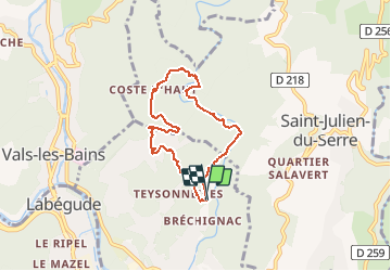
Trail Walking of 6.8 km to be discovered at Auvergne-Rhône-Alpes, Ardèche, Ucel. This trail is proposed by pb07.

Description

Départ Bréchignac. Petit parking 50m après la fin du goudron.
Suivre la vallée du Sandron par un bon chemin large puis montée par sentier.
Après la Coste d'Haut suivre la route. L'ancien chemin passe dans une propriété privée.
Dans le creux du virage, chemin (mal balisé) vers la table d'orientation- très belle vue.

Elevation profile

Positioning

Country:
France
Region :
Auvergne-Rhône-Alpes
Department/Province :
Ardèche
Municipality :
Ucel
Location:
Unknown
Start:(UTM)
610209 ; 4945039 (31T) N.


Close
My subscriptions