


Collonges saint Romain

ppn
User
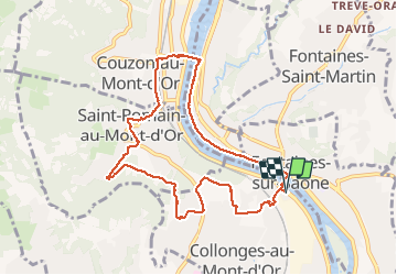

Length
9.2 km

Max alt
317 m

Uphill gradient
174 m
Km-Effort
11.5 km

Min alt
165 m

Downhill gradient
174 m
Boucle
Yes
Creation date :
2019-10-18 06:35:05.643
Updated on :
2019-10-18 10:30:59.9
2h30
Difficulty : Very easy

FREE GPS app for hiking
 SityTrail
IGN / Geographical institutes
SityTrail Plus
The world is yours!
About
Trail Walking of 9.2 km to be discovered at Auvergne-Rhône-Alpes, Métropole de Lyon, Collonges-au-Mont-d'Or. This trail is proposed by ppn.
Positioning
Country:
France
Region :
Auvergne-Rhône-Alpes
Department/Province :
Métropole de Lyon
Municipality :
Collonges-au-Mont-d'Or
Location:
Unknown
Start:(Dec)
Start:(UTM)
643545 ; 5076860 (31T) N.
Comments