


RS-Sardieu-2

raymondfn
User
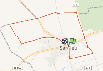

Length
5.5 km

Max alt
357 m

Uphill gradient
39 m
Km-Effort
6 km

Min alt
326 m

Downhill gradient
40 m
Boucle
Yes
Creation date :
2019-10-18 15:56:07.658
Updated on :
2019-10-18 16:04:00.641
1h19
Difficulty : Easy

FREE GPS app for hiking
 SityTrail
IGN / Geographical institutes
SityTrail Plus
The world is yours!
About
Trail Walking of 5.5 km to be discovered at Auvergne-Rhône-Alpes, Isère, Sardieu. This trail is proposed by raymondfn.
Positioning
Country:
France
Region :
Auvergne-Rhône-Alpes
Department/Province :
Isère
Municipality :
Sardieu
Location:
Unknown
Start:(Dec)
Start:(UTM)
673255 ; 5026321 (31T) N.
Comments