


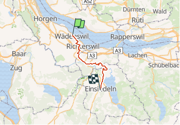
Wädenswil - Einsiedeln

hallauer
User

Length
21 km

Max alt
990 m

Uphill gradient
830 m
Km-Effort
30 km

Min alt
409 m

Downhill gradient
323 m
Boucle
No
Creation date :
2014-12-11 00:00:00.0
Updated on :
2014-12-11 00:00:00.0
--
Difficulty : Unknown

FREE GPS app for hiking
 SityTrail
IGN / Geographical institutes
SityTrail Plus
The world is yours!
About
Trail Other activity of 21 km to be discovered at Zurich, Bezirk Horgen, Wädenswil. This trail is proposed by hallauer.
Description
Pilger"Zubringerweg" mit Schiffsvariante
Positioning
Country:
Switzerland
Region :
Zurich
Department/Province :
Bezirk Horgen
Municipality :
Wädenswil
Location:
Unknown
Start:(Dec)
Start:(UTM)
475388 ; 5230773 (32T) N.
Comments