


le lac luc

bouscaillou
User
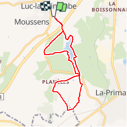

Length
8.1 km

Max alt
693 m

Uphill gradient
164 m
Km-Effort
10.3 km

Min alt
627 m

Downhill gradient
163 m
Boucle
Yes
Creation date :
2019-10-18 15:30:09.786
Updated on :
2019-10-18 17:06:41.093
1h35
Difficulty : Very easy

FREE GPS app for hiking
 SityTrail
IGN / Geographical institutes
SityTrail Plus
The world is yours!
About
Trail Nordic walking of 8.1 km to be discovered at Occitania, Aveyron, Luc-la-Primaube. This trail is proposed by bouscaillou.
Positioning
Country:
France
Region :
Occitania
Department/Province :
Aveyron
Municipality :
Luc-la-Primaube
Location:
Unknown
Start:(Dec)
Start:(UTM)
463051 ; 4906563 (31T) N.
Comments