


CHAUFFAYER la de roaffan circuit 2 o

RobinMicheline
User GUIDE
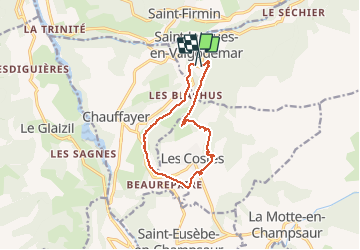

Length
11.4 km

Max alt
1226 m

Uphill gradient
349 m
Km-Effort
16.1 km

Min alt
964 m

Downhill gradient
374 m
Boucle
Yes
Creation date :
2019-10-19 08:11:07.229
Updated on :
2020-01-22 19:46:24.0
4h39
Difficulty : Easy

FREE GPS app for hiking
 SityTrail
IGN / Geographical institutes
SityTrail Plus
The world is yours!
About
Trail Walking of 11.4 km to be discovered at Provence-Alpes-Côte d'Azur, Hautes-Alpes, Saint-Jacques-en-Valgodemard. This trail is proposed by RobinMicheline.
Positioning
Country:
France
Region :
Provence-Alpes-Côte d'Azur
Department/Province :
Hautes-Alpes
Municipality :
Saint-Jacques-en-Valgodemard
Location:
Unknown
Start:(Dec)
Start:(UTM)
265309 ; 4961583 (32T) N.
Comments