


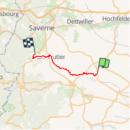
Circuit SA Wintzenheim - Stambach

Tourisme Equestre Alsace
Promouvoir le Tourisme Equestre en Alsace GUIDE+

Length
18.4 km

Max alt
338 m

Uphill gradient
361 m
Km-Effort
23 km

Min alt
218 m

Downhill gradient
337 m
Boucle
No
Creation date :
2014-12-10 00:00:00.0
Updated on :
2019-01-05 19:03:00.367
2h53
Difficulty : Medium

FREE GPS app for hiking
 SityTrail
IGN / Geographical institutes
SityTrail Plus
The world is yours!
About
Trail Horseback riding of 18.4 km to be discovered at Grand Est, Bas-Rhin, Wintzenheim-Kochersberg. This trail is proposed by Tourisme Equestre Alsace.
Description
Circuit SA Wintzenheim - Stambach
Photos


Positioning
Country:
France
Region :
Grand Est
Department/Province :
Bas-Rhin
Municipality :
Wintzenheim-Kochersberg
Location:
Unknown
Start:(Dec)
Start:(UTM)
390530 ; 5390574 (32U) N.
Comments