


Bois et Forets 2013

papyduck
User
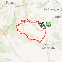

Length
26 km

Max alt
1070 m

Uphill gradient
734 m
Km-Effort
35 km

Min alt
706 m

Downhill gradient
741 m
Boucle
Yes
Creation date :
2014-12-10 00:00:00.0
Updated on :
2014-12-10 00:00:00.0
7h29
Difficulty : Difficult

FREE GPS app for hiking
 SityTrail
IGN / Geographical institutes
SityTrail Plus
The world is yours!
About
Trail Walking of 26 km to be discovered at Provence-Alpes-Côte d'Azur, Var, Comps-sur-Artuby. This trail is proposed by papyduck.
Positioning
Country:
France
Region :
Provence-Alpes-Côte d'Azur
Department/Province :
Var
Municipality :
Comps-sur-Artuby
Location:
Unknown
Start:(Dec)
Start:(UTM)
298638 ; 4846331 (32T) N.
Comments