


depart avanne vers rocher de valmy- thoraise

gerardmicheline
User
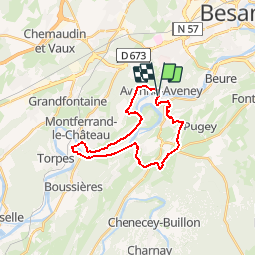

Length
22 km

Max alt
424 m

Uphill gradient
569 m
Km-Effort
29 km

Min alt
223 m

Downhill gradient
569 m
Boucle
Yes
Creation date :
2019-10-21 05:41:32.118
Updated on :
2019-10-21 05:41:32.118

FREE GPS app for hiking
 SityTrail
IGN / Geographical institutes
SityTrail Plus
The world is yours!
About
Trail of 22 km to be discovered at Bourgogne-Franche-Comté, Doubs, Avanne-Aveney. This trail is proposed by gerardmicheline.
Positioning
Country:
France
Region :
Bourgogne-Franche-Comté
Department/Province :
Doubs
Municipality :
Avanne-Aveney
Location:
Unknown
Start:(Dec)
Start:(UTM)
724294 ; 5231560 (31T) N.
Comments