


Montbozon Dampierre-sur-Linotte

gerardmicheline
User
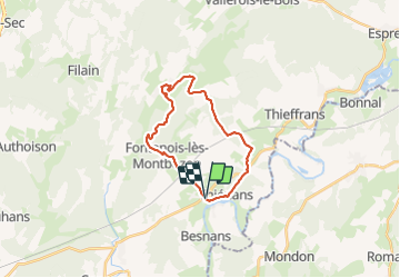

Length
20 km

Max alt
345 m

Uphill gradient
389 m
Km-Effort
26 km

Min alt
243 m

Downhill gradient
393 m
Boucle
Yes
Creation date :
2019-10-21 05:44:38.845
Updated on :
2019-10-21 05:44:38.845

FREE GPS app for hiking
 SityTrail
IGN / Geographical institutes
SityTrail Plus
The world is yours!
About
Trail of 20 km to be discovered at Bourgogne-Franche-Comté, Haute-Saône, Montbozon. This trail is proposed by gerardmicheline.
Positioning
Country:
France
Region :
Bourgogne-Franche-Comté
Department/Province :
Haute-Saône
Municipality :
Montbozon
Location:
Unknown
Start:(Dec)
Start:(UTM)
293558 ; 5260635 (32T) N.
Comments