


Topalihuette-Randa

U106659
User
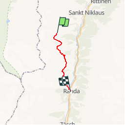

Length
9.9 km

Max alt
2750 m

Uphill gradient
390 m
Km-Effort
19.3 km

Min alt
1404 m

Downhill gradient
1637 m
Boucle
No
Creation date :
2014-12-11 00:00:00.0
Updated on :
2014-12-11 00:00:00.0
--
Difficulty : Unknown

FREE GPS app for hiking
 SityTrail
IGN / Geographical institutes
SityTrail Plus
The world is yours!
About
Trail Other activity of 9.9 km to be discovered at Valais/Wallis, Visp, St. Niklaus. This trail is proposed by U106659.
Description
Grobe Routenplanung
Positioning
Country:
Switzerland
Region :
Valais/Wallis
Department/Province :
Visp
Municipality :
St. Niklaus
Location:
Unknown
Start:(Dec)
Start:(UTM)
404409 ; 5112216 (32T) N.
Comments