


20191022Thivar

Jeanclaudebic
User
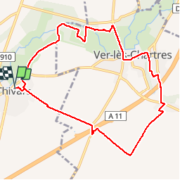

Length
9.7 km

Max alt
154 m

Uphill gradient
67 m
Km-Effort
10.6 km

Min alt
130 m

Downhill gradient
68 m
Boucle
Yes
Creation date :
2019-10-22 06:59:18.49
Updated on :
2019-10-22 09:05:53.051
2h06
Difficulty : Very easy

FREE GPS app for hiking
 SityTrail
IGN / Geographical institutes
SityTrail Plus
The world is yours!
About
Trail Walking of 9.7 km to be discovered at Centre-Loire Valley, Eure-et-Loir, Thivars. This trail is proposed by Jeanclaudebic.
Positioning
Country:
France
Region :
Centre-Loire Valley
Department/Province :
Eure-et-Loir
Municipality :
Thivars
Location:
Unknown
Start:(Dec)
Start:(UTM)
385314 ; 5359705 (31U) N.
Comments