


2019-10-21_11h19m38_K9jqtt1dhLw

gerard70
User
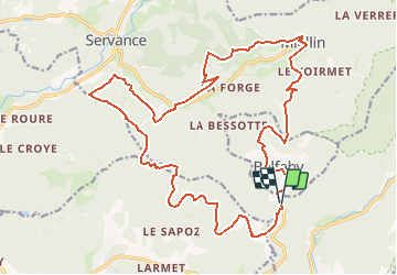

Length
24 km

Max alt
893 m

Uphill gradient
1171 m
Km-Effort
39 km

Min alt
426 m

Downhill gradient
1171 m
Boucle
Yes
Creation date :
2019-10-21 09:19:39.74
Updated on :
2019-10-22 10:39:17.1

FREE GPS app for hiking
 SityTrail
IGN / Geographical institutes
SityTrail Plus
The world is yours!
About
Trail of 24 km to be discovered at Bourgogne-Franche-Comté, Haute-Saône, Servance-Miellin. This trail is proposed by gerard70.
Positioning
Country:
France
Region :
Bourgogne-Franche-Comté
Department/Province :
Haute-Saône
Municipality :
Servance-Miellin
Location:
Servance
Start:(Dec)
Start:(UTM)
330116 ; 5293938 (32T) N.
Comments