


SOTTA 6.4 KM

jpb83
User
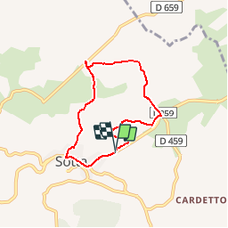

Length
6.4 km

Max alt
98 m

Uphill gradient
79 m
Km-Effort
7.5 km

Min alt
25 m

Downhill gradient
81 m
Boucle
Yes
Creation date :
2019-10-22 19:43:04.686
Updated on :
2019-10-22 19:44:17.537
--
Difficulty : Very easy

FREE GPS app for hiking
 SityTrail
IGN / Geographical institutes
SityTrail Plus
The world is yours!
About
Trail Running of 6.4 km to be discovered at Corsica, South Corsica, Sotta. This trail is proposed by jpb83.
Positioning
Country:
France
Region :
Corsica
Department/Province :
South Corsica
Municipality :
Sotta
Location:
Unknown
Start:(Dec)
Start:(UTM)
516990 ; 4599378 (32T) N.
Comments
facile et agréable