


Montmin / cretes du Fretes / Tournette / Montmin

laurentnecca
User
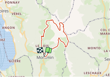

Length
14 km

Max alt
2312 m

Uphill gradient
1332 m
Km-Effort
32 km

Min alt
1019 m

Downhill gradient
1333 m
Boucle
Yes
Creation date :
2019-10-23 06:56:41.915
Updated on :
2019-10-23 18:17:59.5
7h03
Difficulty : Difficult

FREE GPS app for hiking
 SityTrail
IGN / Geographical institutes
SityTrail Plus
The world is yours!
About
Trail Walking of 14 km to be discovered at Auvergne-Rhône-Alpes, Upper Savoy, Talloires-Montmin. This trail is proposed by laurentnecca.
Photos


Positioning
Country:
France
Region :
Auvergne-Rhône-Alpes
Department/Province :
Upper Savoy
Municipality :
Talloires-Montmin
Location:
Unknown
Start:(Dec)
Start:(UTM)
287427 ; 5075846 (32T) N.
Comments