


Mattinata

nave
User
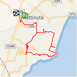

Length
10.5 km

Max alt
229 m

Uphill gradient
288 m
Km-Effort
14.3 km

Min alt
3 m

Downhill gradient
278 m
Boucle
Yes
Creation date :
2019-10-25 11:15:52.63
Updated on :
2019-10-25 19:01:45.684
3h51
Difficulty : Very easy

FREE GPS app for hiking
 SityTrail
IGN / Geographical institutes
SityTrail Plus
The world is yours!
About
Trail Walking of 10.5 km to be discovered at Apulia, Foggia, Mattinata. This trail is proposed by nave.
Description
Promenade autour de Mattinata
Photos


Positioning
Country:
Italy
Region :
Apulia
Department/Province :
Foggia
Municipality :
Mattinata
Location:
Unknown
Start:(Dec)
Start:(UTM)
586933 ; 4617886 (33T) N.
Comments