


lac de bonlieu et belvédère

daniellebou
User
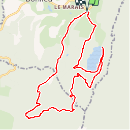

Length
11.3 km

Max alt
988 m

Uphill gradient
280 m
Km-Effort
15.1 km

Min alt
788 m

Downhill gradient
281 m
Boucle
Yes
Creation date :
2019-10-26 08:09:09.544
Updated on :
2019-10-27 22:53:12.104
3h12
Difficulty : Difficult

FREE GPS app for hiking
 SityTrail
IGN / Geographical institutes
SityTrail Plus
The world is yours!
About
Trail Walking of 11.3 km to be discovered at Bourgogne-Franche-Comté, Jura, Bonlieu. This trail is proposed by daniellebou.
Photos


Positioning
Country:
France
Region :
Bourgogne-Franche-Comté
Department/Province :
Jura
Municipality :
Bonlieu
Location:
Unknown
Start:(Dec)
Start:(UTM)
719885 ; 5164432 (31T) N.
Comments