


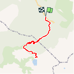
Lac de Crop

GOHIER
User

Length
9.2 km

Max alt
1926 m

Uphill gradient
632 m
Km-Effort
17.7 km

Min alt
1301 m

Downhill gradient
639 m
Boucle
Yes
Creation date :
2019-10-26 12:07:28.0
Updated on :
2019-10-26 16:04:27.638
3h56
Difficulty : Unknown

FREE GPS app for hiking
 SityTrail
IGN / Geographical institutes
SityTrail Plus
The world is yours!
About
Trail Walking of 9.2 km to be discovered at Auvergne-Rhône-Alpes, Isère, Laval-en-Belledonne. This trail is proposed by GOHIER.
Description
A l’ombre...
Positioning
Country:
France
Region :
Auvergne-Rhône-Alpes
Department/Province :
Isère
Municipality :
Laval-en-Belledonne
Location:
Unknown
Start:(Dec)
Start:(UTM)
735038 ; 5012518 (31T) N.
Comments