


Aarschot

JanBekaert
User
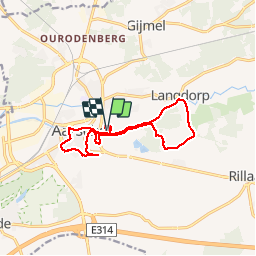

Length
13 km

Max alt
57 m

Uphill gradient
104 m
Km-Effort
14.4 km

Min alt
8 m

Downhill gradient
104 m
Boucle
Yes
Creation date :
2019-10-27 07:06:06.435
Updated on :
2019-10-27 11:38:46.672
4h31
Difficulty : Very easy

FREE GPS app for hiking
 SityTrail
IGN / Geographical institutes
SityTrail Plus
The world is yours!
About
Trail Walking of 13 km to be discovered at Flanders, Flemish Brabant, Aarschot. This trail is proposed by JanBekaert.
Positioning
Country:
Belgium
Region :
Flanders
Department/Province :
Flemish Brabant
Municipality :
Aarschot
Location:
Aarschot
Start:(Dec)
Start:(UTM)
629467 ; 5649869 (31U) N.
Comments